Historic Infrastructure | Trail of History
Episode 40 | 27m 11sVideo has Closed Captions
Explore historic roadways, rail lines, canals and covered bridges of our region.
Meet the folks of Belmont Trolley, working to return historic streetcars to the rails once used by the Piedmont and Northern RR. We head to Fort Mill to explore abandoned segments of Nation Ford Rd. We’ll explore the ruins of Landsford Canal & see why this piece of infrastructure only operated for a decade, and we head to Catawba County to get a look at one of two remaining covered bridges in NC.
Problems playing video? | Closed Captioning Feedback
Problems playing video? | Closed Captioning Feedback
Trail of History is a local public television program presented by PBS Charlotte
Bragg Financial Advisors is an independent, fee-based, family run investment advisory firm. We exist to serve our clients, our employees and our community. We take good care of people.
Support provided by:

Historic Infrastructure | Trail of History
Episode 40 | 27m 11sVideo has Closed Captions
Meet the folks of Belmont Trolley, working to return historic streetcars to the rails once used by the Piedmont and Northern RR. We head to Fort Mill to explore abandoned segments of Nation Ford Rd. We’ll explore the ruins of Landsford Canal & see why this piece of infrastructure only operated for a decade, and we head to Catawba County to get a look at one of two remaining covered bridges in NC.
Problems playing video? | Closed Captioning Feedback
How to Watch Trail of History
Trail of History is available to stream on pbs.org and the free PBS App, available on iPhone, Apple TV, Android TV, Android smartphones, Amazon Fire TV, Amazon Fire Tablet, Roku, Samsung Smart TV, and Vizio.
Providing Support for PBS.org
Learn Moreabout PBS online sponsorship- [Announcer] This is a production of PBS Charlotte.
(gentle music) (gentle music) - [Narrator] Roads, bridges, railroads, ports, and waterways all make up our modern day transportation infrastructure.
It's often overlooked and perhaps maybe taken for granted, but what about some of those forgotten roads, bridges, canals, and railroads?
Coming up meet a volunteer group in Belmont ready to put a dormant rail line back into service using green technology.
Explore the remnants of a Native American trading path that helped to transform the region.
Visit a 19th century canal built to turn the Catawba River into an economic highway.
And meet the group near Hickory protecting one of North Carolina's original covered bridges.
All that and more as we explore forgotten infrastructure of the Carolinas on "Trail of History."
(upbeat music) (gentle music) Downtown Belmont offers a lot to those who find their way onto Main Street.
- [John] Belmont is the place that I think everybody wants to be.
- [Narrator] This former textile town bustles with shops, bars, and restaurants like Sammy's.
- [John] Sammy's is Belmont's version of "Cheers," right?
Everybody knows your name.
It's been in business for about 17 years now and I've owned it for about six and a half.
- [Narrator] Owner John Bailey says, "Downtown Belmont is experiencing a renaissance."
- It's very walkable, and I think that's a great thing and I think that's one of the things that makes people want to come here.
- [Narrator] However, this seemingly perfect little downtown has some connectivity and parking issues.
Just over a mile away sits Belmont Abbey College and it's 1500 students.
The issue, a major interstate, I-85, effectively divides downtown from the school.
- It was a limiting factor for students trying to get back and forth to town, and for the town to get back and forth to the college other than automobile.
- [Narrator] The town is seeking a better way to connect the college.
- Belmont Trolley was an idea that was born about eight years ago.
Really the problem we were trying to solve was how to better link Belmont Abbey College to downtown Belmont.
- [Narrator] And the group's solution, utilize a 1.5 mile section of tracks, once part of the Piedmont and Northern Railroad, a railroad that once connected Charlotte to Mount Holly, Belmont, and Gastonia.
Rob Presley is President of Belmont Trolley.
- And knowing that there was a historic rail line that started in downtown and ran right by the college, the natural thought was is how do we utilize that line?
- [Narrator] The nonprofit group identified three things to make it all come together.
- We were gonna need a track, we were gonna need trolley cars, and we ultimately were gonna need a facility to house the trolley cars in.
We knew that North Carolina Department of Transportation owned the rail line that ran between downtown and Belmont Abbey.
So we approached North Carolina Department of Transportation and they thought it was a wonderful idea and a wonderful use of that section of rail line.
- [Narrator] The next item on the list, they needed a trolley, so they approached the Charlotte Mecklenburg Historic Landmarks Commission and Charlotte Trolley who owned Car 85 and Car 1.
Number 85 is part of Charlotte's transportation history.
It was the last street car to operate in the Queen City and was retired when buses took over the routes.
Decades later, volunteers restored and operated these two cars in Charlotte South End, before being displaced by the Blue Line Light Rail.
(upbeat music) With both Charlotte cars out of service, Belmont Trolley offered to give them a home, but the Historic Landmarks Commission initially declined.
So Belmont Trolley had to go shopping.
- Ended up raising the money and acquiring a vintage trolley car and it was put on a tractor trailer and with much fanfare, driven into downtown Belmont from Canada.
- [Narrator] Now the proud owner of Car 16, Belmont Trolley then got an unexpected call from Charlotte Mecklenburg Historic Landmarks Commission, after their own plans for Car 85 and Car 1 stalled.
- Now Belmont has not only one car, but three cars.
We have a fleet, if you will, that'll be running on the P and N line between Belmont Abbey and downtown Belmont.
(upbeat music) - [Narrator] The third part of the project, they needed a place to keep their small fleet.
- We're gonna be building a facility in downtown Belmont that would be designed to look like an old train station in a small town.
And that facility, in addition to housing the cars, will also serve as a public event venue and an education and history venue for students in Gaston County.
(upbeat music) - [Narrator] Just like the modern street cars and light rail now operating in Charlotte, the cars at Belmont Trolley need electricity.
- We thought long and hard about how to power the three cars.
Trolleys have motors, not engines, and so it has to have a source of power.
- [Narrator] The old Piedmont and Northern Railroad used electric locomotives, but the P and N overhead power lines they used are long gone.
And as for replacing them, Pressly says... - That's not an option for us in Belmont.
The cost to build overhead lines is prohibitive.
And Charlotte used a diesel fire generator that has issues in itself.
(gentle music) We didn't see diesel power generator as an option for us.
- [Narrator] They would need another power solution.
A solution developed by engineering students in this lab at UNC Charlotte.
- Who knew, again, the stars and the moons lining up for Belmont Trolley, but who knew that UNCC had an engineering school dedicated to clean energy for trains?
We ultimately met with them and it was a match made in heaven.
- [Narrator] Since around 2012, researchers and students have been developing hardware and various systems to make railroads cleaner for the environment.
- Our goal is to modify traditional diesel locomotive into electrical one.
- [Narrator] What the team developed might surprise you.
- What we're doing here is called wireless power transfer.
- [Narrator] In some ways it's very similar to charging your phone just on a much larger scale.
- Very similar technology that was invented by Nicola Tesla 120 years ago, but now we're using it for transportation.
So we can charge electric vehicle, we can charge trolleys and even the locomotive train.
- This will help to reduce the amount of carbon emissions that will, that end up adversely affecting our climate, but it also trains our students in how to be prepared for the next generation of technologies.
- [Narrator] The research at UNC Charlotte is paying off.
- [Mason] We are right now the first in the US that applies wireless power transfer technology in the train application.
- Most of the wireless power transfer systems operate about 70% efficiency, whereas our team have been able to develop a system that is over 92% efficient in the transfer of that power from the transmitter to the receiver.
And that is is where the engineering and the research comes into play in order to create a better product for the future.
- [Narrator] As part of the partnership between Belmont Trolley and UNC Charlotte, the researchers and students built this prototype power car.
- That power car is a tandem car that hooks to each one of the trolleys, and has lithium ion batteries that then send electricity currents to the motors in the trolley cars.
- [Narrator] Beyond the advancements in technology, projects like this one also come with intangible rewards.
- It really is exciting because the students, the passion and the energy and the creativity that they bring to a project is just fantastic.
- [Tiefu] It's good opportunity for everybody to learn from a new technology and from each other.
- In the future we could come back to Belmont years from now, see this thing completely running altogether and be like, "Hey, I was a part of that."
- And then when they get to go out into the real world and they get to have such a positive impact on both their industry that they're working in as well as on society, it's very rewarding to see that.
- [Narrator] Back in Belmont, the trolleys wait like stabled horses, eager to get back to work.
The folks at Belmont Trolleys still have to raise around $2 million to complete the project, but they they all believe in the mission.
- You'll see a better access for the students at Belmont Abbey.
It'll be a big draw.
We'll have a lot of people coming into town who normally wouldn't have been.
And so obviously it'll be a big boom to all Belmont businesses.
- [Rob] Think the community as a whole will be amazed at the benefits that this endeavor will bring to the community.
(gentle music) - [Narrator] Did you know that more than 140,000 miles of public road weave between North and South Carolina?
Kind of amazing when you think about it.
(gentle music) For the most part, say other than the traffic jams and stop lights, roads and highways make getting to wherever it is you're going a bit easier.
And well, it's easy to maybe take them for granted.
- You know, we get on the road and we just assume that this is the road and that some city planner came up with this road, you know, maybe 50 years ago or a hundred at the most.
- [Narrator] But well before these paved pathways of mobility provided us with the ability to move freely about the country, there existed something else.
A piece of forgotten infrastructure, a network of pre-historic paths that evolved into our modern road system.
We hit the road to Lancaster, South Carolina and the Native American Study Center where we asked Dr. Steven Chriswell just how indigenous people traveled.
- It's important to know that these paths that we still follow today were created by Native Americans thousands of years ago.
And persistent, you know, if something works human beings keep doing it and they stick with it.
And these paths were clearly the best way to go and the right way to go.
And we owe our ability in some ways to get from one part of the Carolinas to the other, to get to Atlanta, to get to Virginia, because of these paths that were laid out thousands of years ago.
These paths were used for warfare.
War party would follow this path to go and fight.
Partly for trade in peace times.
And those paths became the basis for the trails that settlers would follow, sometimes referred to as the Great Trading Path, the Great War Path, the Great Warrior Path.
And that path then later became the Great Wagon Road.
That was the path used by Scott-Irish settlers who came down from Pennsylvania and then settled into the area, what they called the Waxhaws, which is now the the Charlotte area.
- [Narrator] Amazingly, some segments of these historic paths still exist.
(gentle music) At Anne Springs Close Greenway in Fort Mill, there's a well-preserved section of the Great Wagon Road, known as Nation Ford Road.
- You know, some of the first settlements were all along these trade paths.
When you get to waterways, you start seeing more and more settlement.
That's why Nation Ford was so important, because it was a place to cross the Catawba River a way to get from the, you know, the upper part of the Carolinas to the lower part.
But once particularly, the Scott-Irish started coming in, they liked it enough that they stayed and they settled on Catawba lands.
- [Narrator] Flora Doraski knows a bit about the area's history.
She volunteers at both the Fort Mill History Museum and the Greenway.
- Mostly Scott-Irish coming from the Philadelphia area, coming into this area.
And part of the attraction here was that, especially in the mountains, it reminded them of home, of the highlands.
- [Narrator] Back in the 1700s if early settlers wanted to make the move from Pennsylvania down the Great Wagon Road, they couldn't just call a moving company or hop on a highway.
- They were using Conestoga wagons.
Now, the Conestoga wagon was built in Conestoga, Pennsylvania.
And it is not the field wagon that we think of that's been covered when you think of "Little House on the Prairie."
It was the precursor to the modern semi.
It had two tailgates, one in the front, one in the back.
And the wagon itself was not flat, it was bowed.
(upbeat music) - [Narrator] Now with heavy traffic all around, you might feel like getting around in your car these days is a bit of a burden.
But explore the various segments at the Greenway and you might have a greater appreciation for pavement and four rubber tires.
(upbeat music) A hike along this segment of Nation Ford Road gives you a pretty good idea of the considerable effort Native Americans and the early pioneers had to make just to get around.
- There's some areas that are pretty improved, but there are some areas that give you more of that idea of what it was like to be walking along that wagon.
It'd be narrow.
I wouldn't say that any of those trails are strenuous, but moderate, easy to moderate are most of them.
Lots of roots, lots of rocks.
And it gives you an appreciation for coming through here.
I mean, it's not like modern interstates today.
Though in a way that's what it was in its time.
- [Narrator] While not the multi-lane highways of today, roads like Nation Ford made trade possible amongst Native Americans and European settlers.
According to Chriswell, the Catawba benefited from their unique location along the road.
- Once English and and European settlement started, these paths really became the trade route.
And the Catawba, in some ways acted as the middleman in the deer trade between the European settlers and the other tribes who would acquire deer skins because the Catawba were right at a crossroads there where the trade path came down and split into two directions where you could go toward the English settlements, the European settlements, in one direction, and the Cherokee and other tribal groups, the Saluda and so forth, on in the other direction.
(gentle music) - [Narrator] In 1780, after British forces were defeated at the Battle of King's Mountain, British General Cornwallis, who was headquartered 20 miles away in Charlotte, used Nation Ford Road to retreat, along with around 4,000 troops across the Catawba River and to regroup in Waynesboro, South Carolina.
Almost 85 years later, at the end of the Civil War, Nation Ford Road once again offered an escape route.
This time it was the defeated Confederate President Jefferson Davis, along with his cabinet as they fled Federal troops.
(upbeat music) Eventually segments of the original road were abandoned, like here at the Anne Springs Close Greenway.
But Chriswell says today, most of us don't even realize that much of the Great Trading Path is actually still in use.
- The paths now take the form of the interstates, the the major highways, as I said, highway 21, I-77, I-85, follow much of what was the, the Great Trading Path.
And then there are still portions of it that I think in certain states that some of these paths have become greenways and trails to follow for hikers and so forth.
- [Narrator] So the next time you hop in your car for a little road trip, just think about how the roads we travel originated.
Why does it curve here or go there?
(upbeat music) Commerce and trade often go hand-in-hand with a development of infrastructure.
Along the Catawba River, there's a unique state park known for both its natural beauty and for a 19th century engineering marvel.
- Today we are at Landsford Canal State Park, here in Rock Hill, South Carolina.
- [Narrator] The park encompasses just over 400 acres on either side of the river.
- The most popular thing that people come here for is the Rocky Shoals Spider Lilies.
- [Narrator] The shallow rocky shoals along this section of the Catawba River makes a great habitat for the spider lilies.
But back in the early 1800s these shoals created a barrier for commerce and trade.
With the Industrial Revolution in full swing, textile mills in the northern United States and Europe had an almost insatiable appetite for South Carolina's primary cash crop, cotton.
But the Palmetto State needed an efficient transportation network to get this fluffy white stuff to market.
- So they've surveyed all the river systems in South Carolina and determined that they could get goods down to Charleston from the upstate if you built bypass canals around the shoals.
This canal right here bypassed about 2.5 miles of shoals.
- [Narrator] Prior to the canals construction, the site was the home of William R Davie, who had served in the Revolutionary War and later as governor of North Carolina.
According to James, Davie chose the land with the intent to build a water powered mill.
- He built a mill here so that he can grind corn and also had a saw mill on the outside of it.
And when he built the mill, he designed it with a mile long mill race, which is where, how the water gets from the river through basically a canal or ditch to the mill site so that it can run the wheel to grind the corn and run the saw mill.
- [Narrator] Davie's mill race provided engineers with a head start.
- There was already a mile long canal here, so this became one of the easiest places or, you know, choices for them to build one because they only had to put another mile 1.5 down below it to get the boats back out into the river on the bottom side of the fall.
- [Narrator] The state of South Carolina paid just over $120,000 to build Landsford Canal with plans drawn up by American architect Robert Mills.
He's perhaps best well known for designing the Washington Monument.
The actual construction work took about three years, using both enslaved African Americans and Northern stone masons.
(upbeat music) According to James, Landsford Canal opened 200 years ago in 1823 and was considered critical infrastructure, with a big economic advantage over other transportation means of the day.
- You basically needed a way to get these goods and services down to a port as efficiently as possible.
If we're about 225 miles from Charleston, you pretty much figure boats probably moved about walking speed.
It's gonna take a long time to get that materials down there, but when you're doing it with wagons, it's basically the same thing.
You're not putting strain on animals, you're basically just going with the flow.
- [Narrator] And going with the flow starts here.
- You have an entrance up here.
It's kind of hard to see, but this is a diversion dam.
There's a basic pile of rocks that they just hand-piled out there in the river about three quarters way across.
And it was designed to get the water level on this side a little bit higher so that the water will go into the canal.
Once you got to the lifting locks, this lifting lock down here is about 200 feet long and drops about 18 feet in two stages.
The assumption on these canals are that there were pretty much one way traffic.
One of the cool little tidbits is when all these boats delivering goods got down to Charleston they took the boats apart, loaded the wood on the wagons, brought them back up here, rebuilt the boats, floated them down the water.
This canal operated from about 1823, was its initial opening, to about 1831 to 35.
We've got records that show that the employee that worked here was called a bank ranger, and his last payment was in about 1835, 1836.
- [Narrator] The canal only operated for a little more than a decade.
It and other canals in South Carolina were made obsolete thanks to railroads.
- When the railroads started coming in South Carolina in 1831, I think the main, the first line was they call it the Hamburg Line, which would've been been from Augusta to Columbia.
And once they started spurring off of that and running down to the coast, they found that that was a lot speedier and a lot more secure way to get the goods down to the coastal for shipping.
(upbeat music) - [Narrator] Here's one for you.
Imagine a world without bridges.
These critical pieces of infrastructure make getting around a whole lot easier.
According to the North Carolina Department of Transportation website, as of 2021 the DOT is responsible for the safety and maintenance of more than 13,000 bridges across the state.
(gentle music) But there's one style of bridge, now obsolete by modern standards, that's all but extinct in the Old North State.
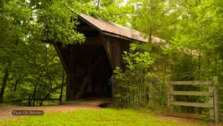
Welcome to the Bunker Hill Covered Bridge in Catawba County.
- Our bridge was built in 1894 to 1895 by Andrew Ramsour and he is known for also building the Horseford Covered Bridge which was eight spans, where our bridge is only one span.
- [Narrator] But it's not the first bridge to span the high banked waterway known as Lyle Creek.
- The Bunker Hill Covered Bridge sits on the Old Island Ford Road, which was laid out over a Native American trail in the 1770s.
Now our bridge was not here at the time, but there was a bridge in place.
- [Narrator] And from the 1770s to the 1940s the crossing saw lots of traffic.
- This was a main road, so you had farm traffic, you had people traffic, you didn't have car traffic yet, so you were having wagons and horses and people.
They did eventually get car traffic.
It was closed to car traffic in the 1920s, and it was open through the 1930s to farm traffic.
So tractors, wagons, horses.
And then by 1940 it was close to that too.
- Today it's the Historical Association of Catawba County that cares for the Bunker Hill Covered Bridge.
- This bridge is very important to Catawba County.
It was donated in 1985 to the Catawba County Historical Association by the Bullock family.
Whenever we get something donated we want to preserve it for future generations.
- Our bridge is one of the last two covered bridges in North Carolina and it is the only one on its original road bed.
I mean, historically there were over 150 covered bridges in North Carolina, there were at least six in Catawba County, and this is the last one.
And it's important because it is a Haupt lattice truss.
Mr. Haupt was from Pennsylvania and he was an engineer from West Point, and he was the first engineer to use mathematical calculations to calculate stress on a bridge.
- [Narrator] According to Marquardt, the bridge structure spent about a decade exposed to the elements.
- The bridge was originally an open span, so you had the timbers across the bottom and the trusses on the side.
- [Narrator] Then around 1905 and motivated by more than aesthetics, the bridge gained its clothes, so to speak, with a pitched roof and siding.
- [Jennifer] And again, it kept the boards from rotting.
That's the main reason they covered it.
- [Narrator] While covering the bridge helped extend the life of the historic span, that doesn't mean it hasn't needed some attention and TLC over the past century.
- It's wood, then wood rots.
Wood gets termites.
It has a tin roof, tin rusts.
So you have to be able to repair the bridge and replace the roof.
And it has been through a lot in its lifetime.
It has survived four floods.
- [Narrator] Recently, upon close inspections, the historic association noticed dangerous erosion undermining the bridge.
They called in a specialist from New Hampshire to come in and make repairs.
- [Bo] So we spent a lot of money and there was a lot of time spent on going in under the bridge and shoring up the abutments so it wouldn't wash out.
- [Narrator] There's a part of the bridge's story that leaves its caretakers in a bit of a quandary, what to do about decades of graffiti.
- We have our original graffiti, which is an advertisement for WA Hoke Farm Implements and Groceries.
And then over top of that we have all the modern neon graffiti.
However, there are different viewpoints on graffiti on covered bridges because our historic graffiti is now historic and we don't want anything to happen to it.
And someday the modern graffiti will be historic.
And so somebody may not want something to happen to it, but us as modern people go, "That looks terrible, why are you desecrating the bridge?"
I really don't know how I feel about it, whether I wanna scrub it off or whether I wanna leave it for future historians to admire.
- [Narrator] Beyond giving safe passage over Lyle Creek, the Bunker Hill Bridge today gives visitors a sense of place.
- Thinking about it, how many wagons came through here?
How many people came?
How many people huddled in the bridge during whatever storm came through?
You know, what were they doing while they were in there?
Were they trading?
Were they standing around talking about the weather?
I don't know, it is fascinating to think about what everybody was doing.
- And it's important us for the history of our children that's growing up, our grandchildren, and our great-grandchildren, that they can come and enjoy this just like their parents and grandparents did.
We're making sure it's not forgotten.
We want to keep it here as long as we can.
(gentle music) - [Narrator] Weather a bridge, canal, road, or trolley, these examples of forgotten infrastructure offer us glimpses into the engineering ingenuity of our regions past.
So the next time you jump in your car, hop a ride on the light rail, or even kayak down the Catawba, take a moment to think about the roads, rails, bridges, and everything else that makes getting around just a little bit easier than it may have been for past generations.
Thank you for watching this episode of "Trail of History."
(upbeat music) (upbeat music continues) (upbeat music) - [Announcer] A production of PBS Charlotte.
(upbeat music fades)
Historic Infrastructure Preview | Trail of History
Preview: Ep40 | 30s | Explore historic roadways, rail lines, canals and covered bridges of our region. (30s)
Providing Support for PBS.org
Learn Moreabout PBS online sponsorship


Support for PBS provided by:
Trail of History is a local public television program presented by PBS Charlotte
Bragg Financial Advisors is an independent, fee-based, family run investment advisory firm. We exist to serve our clients, our employees and our community. We take good care of people.